 |
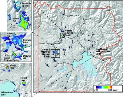
Shaded relief map of Yellowstone with
warm (thermal) areas color coded based
on how much geothermal heat they are emitting per unit area. (Courtesy USGS) |
Thursday, July 12, 2012
USA, Wyoming:
Taking the Temperature of Yellowstone from Space (USGS - Volcano Hazards Program)
We all know Yellowstone is hot… but how hot? And how can we detect park- or basin-wide changes in geothermal areas (regions that let off Earth’s internal heat) that may take place over months, or years? Thermal imaging with satellites has proven highly useful at erupting volcanoes, where magma emerges at very high temperatures. Geothermal areas, though appearing hot on the ground, are more difficult to study from space because their temperatures are much lower and the signal can be masked by solar heating of the ground surface during the daytime.